San Fernando earthquake changed how we prepare for quakes
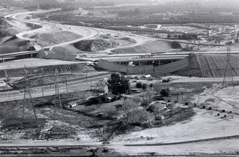
![]() A half-century ago, about an hour before sunrise, the earth under the San Fernando Valley shuddered for a full 12 seconds. Freeway interchanges collapsed. Buildings shifted off their foundations. Water had to be diverted from a crippled dam to avoid a deadly floo
A half-century ago, about an hour before sunrise, the earth under the San Fernando Valley shuddered for a full 12 seconds. Freeway interchanges collapsed. Buildings shifted off their foundations. Water had to be diverted from a crippled dam to avoid a deadly floo![]() d. Nearly 80,000 residents evacuated their homes. The tragic toll: 64 deaths, 2,000 injuries and property damage costing more than a half-billion dollars.
d. Nearly 80,000 residents evacuated their homes. The tragic toll: 64 deaths, 2,000 injuries and property damage costing more than a half-billion dollars.
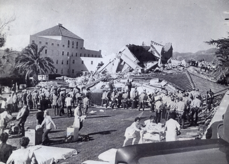
The San Fernando earthquake (also known as the Sylmar earthquake) rumbled along a 12.5-mile fault area beneath the foothills of the San Gabriel Mountains, across the San Fernando Valley in southern California, at about 6:00 a.m. on Feb. 9, 1971. The quake’s epicenter was in the vicinity of Six Flags Magic Mountain, about six miles northeast of Sylmar, at a depth of about seven miles. The unanticipated thrust earthquake had a magnitude of 6.6 with a strong ground motion duration of about 12 seconds as recorded by seismometers, although the whole event was reported to have lasted about 60 seconds. The tremor was felt for 300 miles along the southern California coastal region and as far inland as Las Vegas. In the following weeks, more than 200 aftershocks rattled across the region.
The damage was severe in the northern San Fernando Valley and surface faulting was extensive to the south of the epicenter in the mountains, as well as urban areas. Uplift and other effects affected private homes and businesses. The United States Geological Survey commissioned a private company and the United States Air Force to take aerial photographs over 97 square miles of the mountainous areas north of the San Fernando Valley. The analysis revealed that the earthquake triggered over 1,000 landslides. Highly shattered rock was also documented along the ridge tops, and rockfalls (which continued for several days) were the result of both the initial shock and the aftershocks. The greatest number of slides were centered to the southwest of the mainshock epicenter and close to the areas where surface faulting took place.
While it was not the region’s first big jolt — nor would it be the last — life would never be the same in Southern California. This earthquake was not a natural event the population could ignore. The fault that was responsible for the movement was not one that had been considered a threat, and this highlighted the urgency to identify other similar faults in the Los Angeles metropolitan area. The shaking surpassed building code requirements and exceeded what engineers had prepared for, and although most dwellings in the valley had been built in the prior two decades, even modern earthquake-resistant structures sustained serious damage. As had happened following other earthquakes in California, the devastation led to changes — legislation related to building codes was passed locally and at the state level — to help make California a safer place. The reshaping of laws, zoning rules and construction standards, specifically addressed the construction of homes or businesses near known active fault zones, continues to this day.
Fast facts
- The earthquake spurred the initiation of California’s Strong Motion Instrumentation Program as well as the California Earthquake Clearinghouse program, aimed to coordinate earthquake field investigations and share their observations with scientists, engineers and emergency responders.
- The earthquake revealed the need to retrofit structures. That spurred Los Angeles to adopt an ordinance requiring owners of unreinforced masonry buildings of more than four units to retrofit them, preventing the fall of the structures’ walls.
- The earthquake made an enormous difference in the science of earthquakes, helping scientists to understand the physics of how they occur and how buildings react to the shaking.
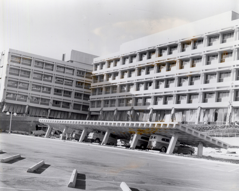
Following the San Fernando event, earthquake engineers and seismologists from established scientific organizations, as well as the newly formed Los Angeles County Earthquake Commission, stated their recommendations that were based on the lessons learned. The list of items needing improvements included building codes, dams and bridges being made more earthquake resistant, hospitals that are designed to remain operational, and the restriction of development near known fault zones. New legislation included the Alquist-Priolo Special Studies Zone Act and the development of the Strong Motion Instrumentation Program.
The Alquist-Priolo Geologic Hazard Zones Act restricts the construction of buildings designed for human occupancy across potentially active faults, to mitigate damage from surface fault rupture. The act was the recognition that structures that were on top of places that had ground rupture or ground failure had suffered catastrophic structural damage.
The state also established the California Strong Motion Instrumentation Program in 1972 — a network of seismometers throughout the state. The monitors provide information on vibrations that the ground experiences adjacent to buildings, bridges and other structures. This enables geologists to study how the ground is shaking outside buildings — vital information for engineers on how to build earthquake-resistant structures. The state also established the California Earthquake Clearinghouse program, which aimed to coordinate earthquake field investigations and share their observations with scientists, engineers and emergency responders.
The California Geological Survey began creating maps of known active faults over the last 12,000 years. Since it is presumed that surface rupture will likely take place where past surface displacement has occurred, the state geologist was given the responsibility for evaluating and mapping faults that had evidence of Holocene rupture and creating regulatory zones around them called earthquake fault zones. State and local agencies (as well as property owners) were then responsible for enforcing or complying with the building restrictions. It continues to require that structures built in those areas are well-engineered.
In 1977, Congress passed the Earthquake Hazards Reduction Act, which was followed by the National Earthquake Hazards Reduction Program, leading to policy recommendations that eventually helped the city of Los Angeles enact an ordinance to retrofit buildings vulnerable to collapse during a strong quake. The program is also credited with funding seismic networks and helping to provide research data.
Related
- In episode 35 of Getting Through It with expert seismologist Dr. Lucy Jones, the science, damage and lasting impact that the first large earthquake in modern Los Angeles had on the city and how we now address earthquake risk across the country is addressed. What was learned created new laws, funding streams and approaches to manage earthquake risk.
- In early 1971, the San Fernando Valley was the scene of a dense network of strong-motion seismometers, which provided a total of 241 seismograms. This made the earthquake the most documented event, at the time, in terms of strong-motion seismology. Part of the reason there were so many stations to capture the event was a 1965 ordinance that required newly constructed buildings in Beverly Hills and Los Angeles over six stories in height to be outfitted with three of the instruments. This stipulation ultimately found its way into the Uniform Building Code as an appendix several years later. One hundred seventy-five of the recordings came from these buildings, another 30 were on hydraulic structures, and the remainder were from ground-based installations near faults, including an array of the units across the San Andreas Fault.
Following many of California’s major earthquakes, lawmakers have acted quickly to develop legislation related to seismic safety. In the aftermath of the magnitude 6.4 Long Beach earthquake in 1933, the Field Act was passed, which governs the design and construction standards for schools. After the 1989 Loma Prieta earthquake, the Seismic Hazards Mapping Act and Senate Bill 1953 (hospital safety requirements) were established. Each earthquake results in new findings and the state’s building standards code has been updated about 15 times since the quake of 1971. Additionally, building materials are required to be tested by a Division of the State Architect certified testing lab to ensure quality and safety; soil testing and geotechnical considerations be conducted to ensure seismic risks are mitigated; additional bracing installed to keep ceilings from collapsing; and construction must be monitored and certified by Division of the State Architect inspectors.
The 1971 San Fernando/Sylmar quake also prepared the city for another devastating earthquake that would strike San Fernando Valley neighborhoods nearly 20 years later — the 1994 Northridge earthquake, which killed 60 people, injured 9,000 and cost the region $20 billion in property damage. The Northridge earthquake also shared several key attributes with the San Fernando/Sylmar event: both were brought about by thrust faults in the mountains north of Los Angeles, each resulting earthquake was similar in magnitude, both occurred in urban and industrial areas and resulted in significant economic impairment, and each event drew critical observation from planning authorities and has been thoroughly studied in the scientific communities. And yet, the damage could have been worse had the Northridge region not been working to tighten building standards, improve the infrastructure and make other changes in response to the San Fernando/Sylmar event.
In all, it’s astonishing to consider how influential the 1971 San Fernando/Sylmar earthquake has been in the 50 years since it hit Los Angeles. With a demonstrated success in retrofits and investment in infrastructure and seismic resilience statewide, the state owes its earthquake resilience to this seismic milestone event.
California Earthquake Authority Looks Back: The 1971 San Fernando Earthquake
Today marks 50 years since the 1971 San Fernando earthquake, also known as the Sylmar quake, injured thousands of people in Los Angeles County. This magnitude 6.6 event lives as another one of California’s most influential earthquakes for science, engineering, preparedness and mitigation.
About the Author

Tara Lukasik is an editor for the International Code Council, working out of its Western Regional Office in Southern California. Starting with the International Conference of Building Officials as the managing editor of its Building Standards Magazine, she has more than 25 years of experience in writing and editing feature content and advancing digital newsletters and magazines from conception to completion. She is currently putting her experience to good use managing the Code Council's Building Safety Journal and its BSJ Weekly newsletter, which connects construction professionals with the Code Council community and the latest industry news and resources. A California native, she enjoys volunteering in her local community and exploring the Golden State with her husband and three spoiled dachshunds. Follow her on Twitter @ICCTLukasik and Linkedin at linkedin.com/in/taralukasik.